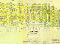
 The elusive map has been found. I believe it is from the Lewis Mumford NY State Collection, but no longer on the site. Of the various wards, this one (Ward 7) had some of the heaviest densities. On the square block consisting of Monroe, Clinton, Cherry and Jefferson the density is 1,170 people per acre. The coloration is hard to decipher. The shades of yellow I would guess is more Polish/Russian than Italian.
Tuesday, August 16, 2005
1903 Density and Ethnicity Map
 The elusive map has been found. I believe it is from the Lewis Mumford NY State Collection, but no longer on the site. Of the various wards, this one (Ward 7) had some of the heaviest densities. On the square block consisting of Monroe, Clinton, Cherry and Jefferson the density is 1,170 people per acre. The coloration is hard to decipher. The shades of yellow I would guess is more Polish/Russian than Italian.
Subscribe to:
Post Comments (Atom)


No comments:
Post a Comment