 I have to get away from the La Dolce Bello posts for a while, otherwise folks might think this is Page 6 of the NYPost. But, mark my words, someday it will be revealed that a certain DOE Region has its own version of "Pagegate." Anyway, I've been struggling with a way to integrate technology with the defining concepts of neighborhoods and communities and how that relates to geography and other larger abstractions. Forget about trying to use textbooks with kids in special need classes, and adding insult to injury, forget about utilizing this month's TC verbiage (garbiage) like "small moments," "reading with your mind on fire," and "improving volume and quality." The big neighborhood map of Harlem worked somewhat, but what I needed were more local images to illustrate in a concrete way things like transportation, jobs, housing etc. and the elusive geographic factor. I didn't want to spend a day taking pics. I finally remembered the A9 map site, but that's gone. Finally I remembered the excellent NYC Bridge and Tunnel site. In this slide show I extracted images from the 145th Hamilton Heights page and the Marcus Garvey page. It helped to explain why certain neighborhoods differed because of geography. The hills in Hamilton Heights vs. the open spaces of Marcus Garvey Park. I also explained that the kind of geography that exists in Marcus Garvey Park is what is underneath Hamilton Heights, except under Hamilton Heights, and more so in Washington Heights, there are more hills. I added too, samples the excellent work that Ms. Asis is doing with special needs first and second graders using neighborhood mapping. Ms. Asis is truly Aces
Sunday, October 22, 2006
Neighborhood Explorations
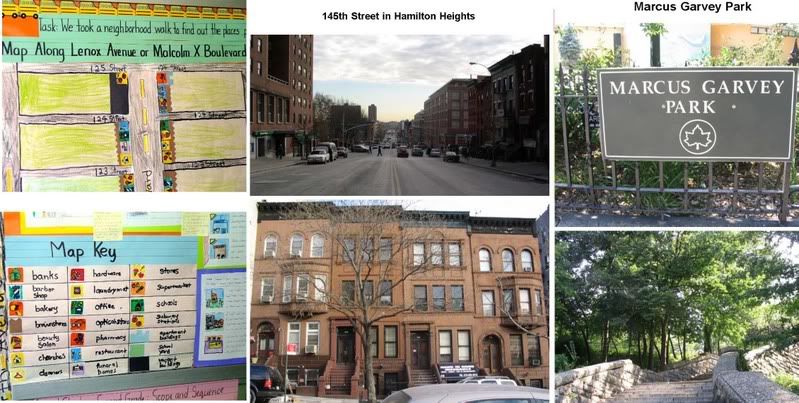
I have to get away from the La Dolce Bello posts for a while, otherwise folks might think this is Page 6 of the NYPost. But, mark my words, someday it will be revealed that a certain DOE Region has its own version of "Pagegate." Anyway, I've been struggling with a way to integrate technology with the defining concepts of neighborhoods and communities and how that relates to geography and other larger abstractions. Forget about trying to use textbooks with kids in special need classes, and adding insult to injury, forget about utilizing this month's TC verbiage (garbiage) like "small moments," "reading with your mind on fire," and "improving volume and quality." The big neighborhood map of Harlem worked somewhat, but what I needed were more local images to illustrate in a concrete way things like transportation, jobs, housing etc. and the elusive geographic factor. I didn't want to spend a day taking pics. I finally remembered the A9 map site, but that's gone. Finally I remembered the excellent NYC Bridge and Tunnel site. In this slide show I extracted images from the 145th Hamilton Heights page and the Marcus Garvey page. It helped to explain why certain neighborhoods differed because of geography. The hills in Hamilton Heights vs. the open spaces of Marcus Garvey Park. I also explained that the kind of geography that exists in Marcus Garvey Park is what is underneath Hamilton Heights, except under Hamilton Heights, and more so in Washington Heights, there are more hills. I added too, samples the excellent work that Ms. Asis is doing with special needs first and second graders using neighborhood mapping. Ms. Asis is truly Aces
Subscribe to:
Post Comments (Atom)


No comments:
Post a Comment